
Geodetic Surveys
A geodetic survey determines the precise position of permanent points on the earth's surface, taking into account the shape, size and curvature of the earth. Geodetic surveying techniques are applied when areas or distances involved are so great that desired accuracy and precision results cannot be obtained by ordinary or plane surveying. Geodetic measurements are now being done with the use of orbiting satellites that are positioned 12,500 miles above the surface of the earth.
The Field Surveys Section defines and manages a consistent coordinate system based on latitude, longitude and heights throughout Missouri. This section is responsible for preservation and augmentation of the horizontal and vertical-control network in Missouri. Electronic distance measurement equipment baselines throughout the state are used to validate and verify these instruments. The Missouri Geographic Reference System (GRS) is an extension of the National Spatial Reference System (NSRS). Currently, there are more than 13,000 of these monuments in Missouri. The technical data for these markers are available through the Land Survey Program.
- EDM Baseline Calibration
- Harn Network
- Horizontal Control Projects
- Horizontal and Vertical Control Map
- Mark Maintenance
- Vertical Control Projects
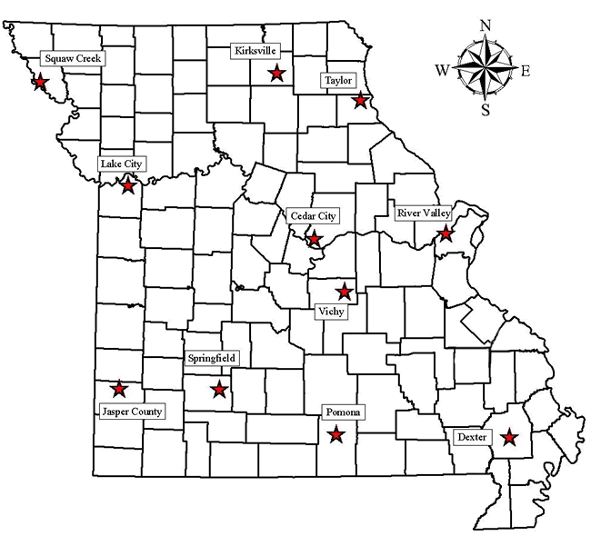
EDM Baseline Documentation
An Electronic Distance Measuring (EDM) calibration will allow the operator to verify the EDM system constant and scale factor. If the EDM, Prisms, Tribrach are in calibration and the correct atmospheric corrections are applied, the results will be reflected in the returned report. If the system constant and/or the scale factor are not within the prescribed limits, the report will notify the sender. To access the information for an Electronic Distance Measuring (EDM) Calibration Baseline, click the appropriate baseline location on the map below.
The Department has changed all fill-in forms to PDF fill-in. You will be able to save and reuse these PDF forms. However, you will need Adobe Acrobat Reader 7 or higher to save the PDF fill-in form.
Land Survey Program - EDM Baselines
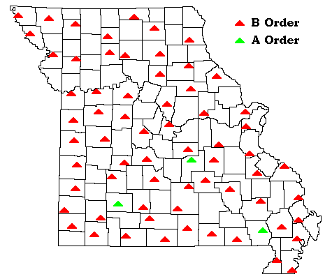
Harn Network
Description: A HARN (High Accuracy Reference Network) is a statewide or regional upgrade in accuracy of NAD 83 coordinates using Global Positioning System (GPS) observations. HARNs were observed to support the use of GPS by Federal, state, and local surveyors, geodesists, and many other applications. The cooperative network upgrading program began in Tennessee in 1986. The last field observations were completed in Indiana in September 1997 after horizontally upgrading some 16,000 survey stations to A-order or B-order status. Horizontal A-order stations have a relative accuracy of 5 mm +/- 1:10,000,000 relative to other A-order stations. Horizontal B-order stations have a relative accuracy of 8 mm +/- 1:1,000,000 relative to other A-order and B-order stations Of these 16,000 stations, NGS has committed to maintaining about 1,400 survey stations, named the Federal Base Network, and the various states will maintain the remainder.
Status: Adjustment of the Missouri HARN was completed in March 1998
| PID | Name | County |
|---|---|---|
| LE0139 | M 16 | Adair |
| LF1452 | C 342 | Atchison |
| KC0716 | MEXPORT | Audrain |
| GF0946 | CASSPORT | Barry |
| AE5420 | BR-01 | Barton |
| AE5421 | BT-02 | Bates |
| JD0046 | BOONE 2 | Boone |
| KE15886 | P 340 | Buchanan |
| GE1106 | BLUFFPORT 2 | Butler |
| GE1108 | EARLPORT AZ MK | Butler |
| JD2573 | CAMDENTON | Camden |
| HB1837 | CG-03 | Cape Girardeau |
| JE2070 | FAA MO85 A | Cass |
| AE7149 | CLN 01 | Clinton |
| AE7150 | CO 02 | Cole |
| HC1137 | POPULATION CENTER | Crawford |
| AE7151 | R E MYERS | Dent |
| GF1009 | AVAPORT AZ MK | Douglas |
| GE1111 | KENNPORT | Dunklin |
| AC6226 | FR-79 | Franklin |
| AE2143 | GE01 | Gentry |
| HD1486 | W 343 | Greene |
| LE0607 | TRENTPORT | Grundy |
| JD2788 | CLINTPORT | Henry |
| HD0568 | Y 32 | Hickory |
| LF1464 | Z 337 | Holt |
| GE1115 | PLAINPORT | Howell |
| KE1114 | W 328 | Jackson |
| HE1218 | JS 009 | Jasper |
| JC0452 | TT 11 L | Jefferson |
| JD2822 | SKYPORT | Johnson |
| HD1521 | LEBAPORT | Laclede |
| KD1350 | LEXPORT AZ MK | Lafayette |
| GF0944 | ETHRIDGE | Lawrence |
| LD0564 | L 15 | Lewis |
| KD1334 | BROOKPORT | Linn |
| AE8203 | LV-01 | Livingston |
| AE7148 | MA 04 | Macon |
| JC1765 | ROLLA NATL PORT | Maries |
| AE8202 | K52 A | Monroe |
| JC0644 | F 103 | Montgomery |
| JD0280 | SAILLES RESET | Morgan |
| GD1176 | P 274 | New Madrid |
| GG0930 | NEOPORT | Newton |
| LF0151 | C 20 | Nodaway |
| AE3000 | OR-01 | Oregon |
| GF0018 | TTS C 19 | Ozark |
| GD1025 | G 279 | Pemiscot |
| GD1719 | COTTON 2 RM 5 | Pemiscot |
| HB1394 | R 323 | Perry |
| JD2820 | SEDPORT | Pettis |
| AE1679 | LAND SURVEY BASE | Phelps |
| AE8201 | H19 A | Pike |
| HD0859 | X 22 | Polk |
| AE2144 | PT01 | Putnam |
| KD1075 | BRADLEY | Randolph |
| AE8205 | RE-06 | Reynolds |
| AE3007 | RP 05 | Ripley |
| KD0972 | MARSHALL RESET | Saline |
| GD1904 | SIKEPORT | Scott |
| GD1905 | SIKEPORT AZ MK | Scott |
| AA8597 | SC 06 | St. Charles |
| HC1125 | FARMPORT | St. Francois |
| AA8662 | SL 21 | St. Louis |
| GD1884 | DEXTPORT | Stoddard |
| AE3009 | TA-05 | Taney |
| AE7152 | TE 01 | Texas |
| HD1412 | CABOOL PORT | Texas |
| HE0915 | NEVADA AIRPORT | Vernon |
| AE7153 | WY 15 | Wayne |
| HD1452 | G 347 | Webster |
Mark Maintenance
Description: Destruction of survey monuments is a violation of Missouri law. The Land Survey Program will replace monuments that are in danger of being damaged or destroyed.
How to Report: Report any monuments that may be in danger of destruction to the Program at 573-368-2300.